Translations by gtranslate.io
Sidebar
manual:user_guide:points:locus_maps_pois
This is an old revision of the document!
Table of Contents

LoPoints (BETA)
This function is not fully developed yet.
LoPoints, the database of OpenStreetMap points of interest is an integral part of LoMaps. In Locus Map, it can be displayed not only on maps but also as an autonomous database which you can browse and search.
LoPoints screen
- Menu > More functions > LoPoints (BETA)
- topbar
 - when particular points are selected, the button changes and displays a number of them on the map. Tapping this removes highlighting of selected points on the map.
 - with this, all LoMaps POIs on the map can be displayed or hidden
- LoMaps file - select a file with the POI database. It is identical to the LoMaps file. It is possible to select one file only.
- Points around - displays a list of all nearest points across all folders around your current position or position of the center cursor
- Search - full-text search of POI. Entering the first few characters returns results that can be further refined.
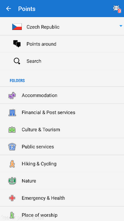
- list of POI categories - Accommodation, Financial&Post services, Culture&Tourism, Public services, Hiking&Cycling, Nature, Emergency&Health, Places of Worship, Food&Drink, Shopping, Sport leisure, Car services, Transportation
Browsing
LoPoints database consists of several categories, e.g. Accommodation, Financial&Post services, Culture&Tourism etc. Each category is sub-divided into subcategories and also contains a special parameter “around” that allows browsing points around the current location of the user.
Points in a selected category can be highlighted on map by tapping ![]() in topbar (showing also number of points in the selected category):
in topbar (showing also number of points in the selected category):
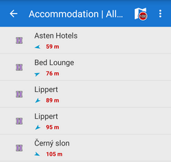
When you tap a particular point its detail info screen opens. All points in categories are always sorted by distance from the map screen cursor (or from the user's location if the device is GPS fixed and the map centered).
It is not possible to export LoPoints. Only a highlighted display is allowed.
Search
Full-text search of names and keywords. E.g. keyword “pub” returns all points with “pub” in their name, description or amenity. 
Deactivation
LoPoints can be deactivated - hidden on the map. Tap ![]() in the topbar and uncheck Display on map.
in the topbar and uncheck Display on map. 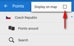
LoPoints database (mapname.osm.db) can be used only when a corresponding LoMap map file (mapname.osm.map) is present in /mapsVector/ directory. If the map file is removed (e.g. due to saving space for use of other map) the POI file cannot be initialized.
manual/user_guide/points/locus_maps_pois.1579873370.txt.gz · Last modified: 2020/01/24 13:42 (external edit)
Except where otherwise noted, content on this wiki is licensed under the following license: CC Attribution-Share Alike 4.0 International
