Translations by gtranslate.io
Sidebar
manual:user_guide:settings:lang_units
This is an old revision of the document!

Language & Units
Language
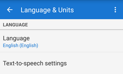 Application language setting. Changing language requires restarting application to take effect.
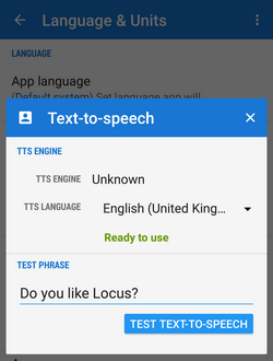
Text-to-speech settings - TTS is useful for guiding and navigation.
- TTS Engine - list of installed engines and corresponding languages. May require additional Google Play downloads in case your language is not supported.
- Locus Map
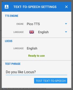 - currently set application language. It is important to have identical localization of your TTS engine and Locus Map so that TTS works properly. Otherwise you will be notified that the selected language is not supported.
 - Test phrase - write any phrase to test your TTS setting
Coordinates
Coordinates type - select type of coordinates to display in the top panel:<html><br></html> World:<html><br></html>
- Lat/Lon (WGS) - classic geographic coordinates, the most widespread
- MGRS - military coordinate system
- Maidenhead - Maidenhead Locator System
- UTM - Universal transverse Merkator
Ireland:<html><br></html>
- OS Irish Grid - modified OSGB 1936 used in United Kingdom
Switzerland:<html><br></html>
- CH1903/LV03
United Kingdom:<html><br></html>
- OSGB 1936 - British National Grid
For advanced users (surveyors, professionals…) who want to use Locus Map for specific tasks there is option to define custom coordinate systems >>
Lat/Lon format - WGS Latitude/longitude format to display:
- xx,xxxxx°
- xx°xx.xxx' - used in geocaching
- xx°xx'xx.xx“ - the most accurate
Units
Length units - wide choice of default length units to work with in the application:
- metric - m, km
- imperial - ft, yd, mi
- nautical - m, nmi
Area units - select units common in your location
Altitude units - units of height above the sea level - meters or feet
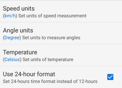
Speed units - select units common in your location - terrestrial or nautical
Angle units - select units you are used to work with
Temperature units - Celsius or Fahrenheit
24-hrs time format - use 24 hour format instead of 12-hour format
manual/user_guide/settings/lang_units.1439990343.txt.gz · Last modified: 2015/08/19 15:19 (external edit)
Except where otherwise noted, content on this wiki is licensed under the following license: CC Attribution-Share Alike 4.0 International
