Translations by gtranslate.io
User Tools
Sidebar
manual:user_guide:tracks:import
This is an old revision of the document!
Table of Contents

Tracks Import
About
 Import is used when you want to work with tracks from external sources - route planning websites, databases, applications etc. Either you choose the data yourselves or Locus Map receives them. There are several ways how to launch the import:
- Menu > More > Import data
- Data > Top panel menu > Import
- Data > Tracks tab > any folder menu > Import - imports directly into the selected folder
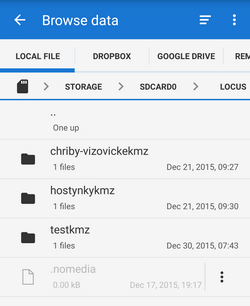
Locus Map file manager
Locus Map opens a file manager window displaying three tabs where to choose files to import. Importable files are in full color and are clickable. More about supported formats see here >>
- Local file tab - directory structure of your device memory. Importable files are usually stored in SDCARD folder.
- Dropbox tab - directory structure of your Dropbox folder
- Remote file tab - contains socket for inserting URL of a remote file stored in a internet repository (Rapidshare, Mega, Mediafire etc.)
Import dialog
After selecting the file or receiving it from some external application Locus Map analyses it and modifies the import dialog according to the content - the dialog can process tracks or points or both of them at once.
Tracks import dialog
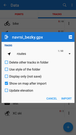 Appears when the imported file contains just tracks:
- Topbar - displays the file name
- Folder selector - selects the folder into which the file will be imported. It is possible to create a new folder directly from the menu - select Add new folder. If you started import from a folder action menu in Data manager it is already pre-selected.
- Empty selected folder - deletes all tracks in the selected folder before the import
- Display only (not import) - the import is unfinished, the track is not saved, just displayed on the map - useful for quick preview of imported file
- Show on the map after import - imports track according to settings and displays them on the map
- Fill altitude - updates altitude information of imported trackpoints (only if the elevation data is available)
- Bottombar - contains Cancel button aborting whole operation and Import button to confirm and start importing.
When importing track and detached waypoints in one imported file Locus Map offers connecting the waypoints with the track so that they are displayed in track chart.
Supported file formats
Locus Map tracks import supports following file formats:
 KML and KMZ
Supported both for Import and Export
Keyhole Markup Language is XML based plain text format with really wide range of usage. Since the version 2.2 KML format is standardized by OGC so it is used by many web/desktop/mobile applications as well as Locus Map.
 GPX
GPX
Supported both for Import and Export
GPS eXchange format is an XML based text format used for handling points, tracks and routes. Locus fully supports all valid tags. More detailed description of GPX format is available on this Wikipedia page.
 TCX
TCX
Supported both for Import and Export
Training Center XML is a data exchange format introduced as part of Garmin's Training Center product. The XML is similar to GPX since it exchanges GPS tracks, but treats a track as an Activity rather than simply a series of GPS points. TCX provides standards for transferring heart rate, running cadence, bicycle cadence, calories in the detailed track. It also provides summary data in the form of laps.
Import settings
- Menu > Settings > Miscellaneous
Track color and transparency
Sets default color of all recorded, imported or manually created tracks.
Track width
Sets default width of all recorded and imported tracks and manually created routes.
manual/user_guide/tracks/import.1438008571.txt.gz · Last modified: 2015/07/27 16:49 (external edit)
Except where otherwise noted, content on this wiki is licensed under the following license: CC Attribution-Share Alike 4.0 International
