Translations by gtranslate.io
Sidebar
manual:user_guide:functions:navigation:settings
This is an old revision of the document!
Table of Contents

Navigation Settings
Navigation Data Source
Locus Map does not contain its own service for calculating routes. Therefore, Route planner and Navigate to features cooperate with third party routing engines - navigation data sources. Each source has specific properties, some is functional online-only, some works offline (after downloading offline navigation data):
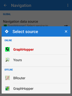
ONLINE
- GraphHopper - very fast and data-efficient routing service. Suitable for all ordinary outdoor activites - three kinds of bike profiles: cycle, MTB and racing and two types of walk profiles: walk and hike. GraphHopper offers also a car navigation profile.
- YOURS- open source routing engine offers point-to-point route calculation suitable for guidance without voice commands. Very good results in calculating bike routes.
Interesting comparison of OpenStreetMap online routing engines can be found here >>
OFFLINE
- BRouter - this service requires installation of an independent application BRouter and downloading offline navigation data:
- launch BRouter from your device
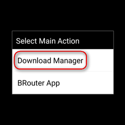
- select Download manager
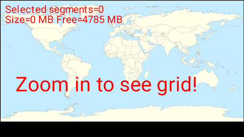
- zoom in and select the area you need for offline routing
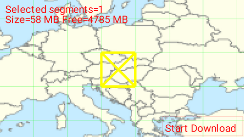
- Confirm downloading of the selected data file.
Offline routing engine BRouter offers much more sophisticated profile settings than any other services. Not only you can add more conditions relevant to various means of transport,
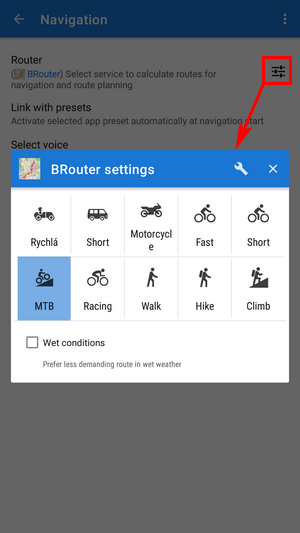
you can also change the profile selection:
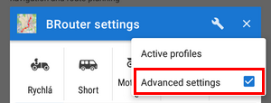
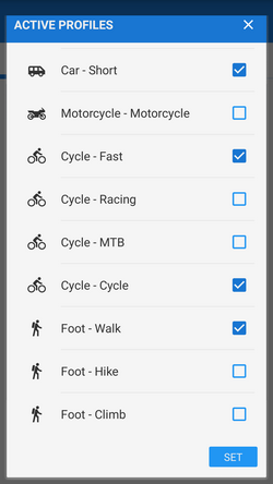
BRouter can be used also with custom (non-Locus) profiles which is a bit advanced problematics. More info can be found here >>
- GraphHopper - BETA version of an offline version of the routing engine. This option is displayed when a special add-on is installed. More information here >>
Link with presets
Linking with the app presets enables fast re-setting of the whole app after the navigation start so that its preferences are better suitable for navigation. E.g. cursor is shifted, map rotation is on, the screen is turned permanently on etc. Three most used navigation profiles can be linked - walking, biking and motor vehicle:
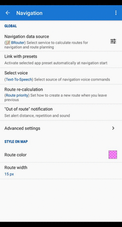
Select voice
- No voice - voice commands are disabled
- Text-to-speech - Android text-to-speech automatic system.
It is possible to download other voice sets from the Locus Store or from Locus community. Voice is set in Language&Units settings section.
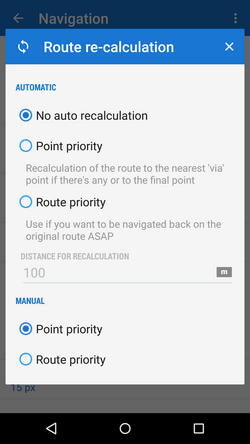
Route re-calculation
AUTOMATIC
This option is available to Locus Map Pro users only.
 Navigation route is recalculated automatically if the deviation from the former route is greater than the parameter distance for recalculation. If you don't follow the recalculated route, Locus Map will recalculate it once again after 30 seconds. You will need internet connection in case an online routing service is selected (e.g. GraphHopper Online or YOURS). For offline routing it is necessary to additionally download and install BRouter co-app and download offline routing data. There are 3 options:
- No auto recalculation - the function is switched OFF - Locus switches to guidance to the nearest point of the original route
- Point priority - Locus recalculates the route to the nearest transit (or 'via') point on the planned route. If there are no 'via' points, it recalculates the route to the final point.
- Route priority - used when you deviate from the original line and want to get back to it - Locus navigates you to the original line as soon as possible and on the nearest place - the line (route) matters.
MANUAL
Settings for manual recalculation that can be triggered from navigation panel.
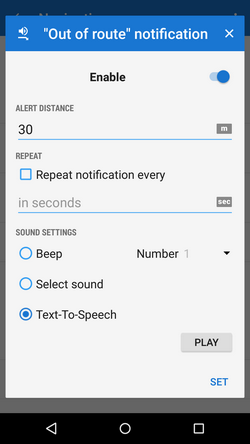
Out of route notification
Check this option if you want Locus Map to warn you when you accidentally leave your route. Set the alert distance, alert repetition and type of sound (beep, voice…):
Line style
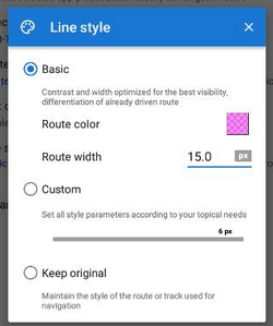
- Basic - in default settings, the line width and color it is optimized for the best visibility. Anyway, it is possible to change them.
- Custom - you can set all parameters of the line style Locus Map offers in its line style editor
- Keep original - when you navigate an already existing route (imported, planned, recorded track…) and you want to maintain its line style during navigation, select this option.
Advanced settings
Strict route following
Each route consists of a chain of routepoints (sort of breadcrumbs). This option navigates strictly from one routepoint to another. When you make a deviation, it tries to get you to the last omitted routepoint.
Keep in mind that this feature may come into conflict with your intentions e.g. when making unwanted detour and part of the original route is not accessible - it will keep navigating you to the first missed routepoint. If you want to skip a routepoint, switch it manually to the next nearest point in the Navigation control menu.
This feature does not work when Auto-recalculation with Point priority is ON.
Maximum allowed deviation
Sets maximum allowed deviation from the route before switching navigation to guidance
Snap to route
Ignores slight inaccuracies of GPS positioning and maintains the navigation cursor position on the navigated route
Frequency of commands
Manually drawn or imported routes do not contain navigation commands so when you select navigation along such a route, Locus has to generate the navigation commands according to the shape of the line. This setting defines how often you are prompted of direction changes on the route: none - low - medium - high.
Two commands at once
When two turns of a route follow closely, Locus Map notifies of both of them at once. Unchecking divides the navigation command into two separate ones.
Stop navigation at route finish
When checked, the navigation is stopped and navigation panel removed when you get to the finish of your route
Navigation cursors
Here you can select set of navigation cursors and set their size (50%-400%)
manual/user_guide/functions/navigation/settings.1574780920.txt.gz · Last modified: 2019/11/26 15:08 (external edit)
Except where otherwise noted, content on this wiki is licensed under the following license: CC Attribution-Share Alike 4.0 International
