Translations by gtranslate.io
Sidebar
manual:user_guide:tracks:recording:profiles_settings
This is an old revision of the document!
Table of Contents
Recording Profiles Settings
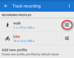
Tracks are recorded in Locus within a particular recording profile which is a set of parameters defining various aspects of the recording. Settings of these parameters can be accessed from:
- Locus settings > Track recording > particular recording profile

- slide-out track recording control panel > Track recording settings > particular recording profile
 * bottom track recording control panel > Track recording settings > particular recording profile

In these settings you can edit an already created profile. If you want to add a new one (Locus Map Pro only), go up one level in the settings hierarchy (settings > track recording).
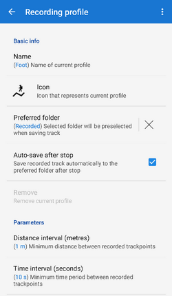
Basic info
- Type of activity - select activity performed on recorded track - walk, hike, bike etc.
- Name - insert name of the profile
- Preferred folder - select which folder will be used for storing recorded tracks from this profile. Default is Last used. If you need a new folder, please go to the track manager first.
- Auto-save after stop - check to save recorded tracks automatically into the preferred folder immediately after the recording is stopped. Option is active only when other than Last used folder is selected.
- Remove - deletes profile, available only to Locus Map Pro users
Parameters
- Distance interval - sets distance between recorded trackpoints. The slower movement, the shorter the distance should be.
- Time interval - sets time period between recording two trackpoints. The slower movement, the longer the period should be.
- Recording conditions - defines method of trackpoint recording based on distance and time intervals:
- Distance AND time - both intervals at once trigger trackpoint recording - smoother line but less accurate
- Distance OR time - one of the intervals triggers trackpoint recording - very accurate but a lot of trackpoints recorded
- Required accuracy - sets maximum acceptable range of GPS accuracy for recording trackpoints
- Record only when moving - track recording is running only provided Locus Map detects movement of the device. If not, the recording is paused.
Sometimes, location indicator is moving on map even when speed is 0 m/s. That is caused by post-processing of raw GPS data in the device and insufficient amount of data. By enabling this feature, Locus Map stores only correct trackpoints.
- Record when GPS is off - track recording proceeds even if the GPS signal is out, e.g. in buildings. Location is acquired by wifi and mobile networks and can be approximate only.
Accuracy of such recording may reach even a few kilometers out of your real position or may result in no recording due to low values in Required accuracy parameter.
Style on map
- Limit trackpoints on map - limits number of visible trackpoints of actually recorded track. Recommended for long or frequent routes. Too long recording (too many trackpoints) may slow down the display of maps.
- Number of trackpoints - defines number of visible recorded trackpoints on map in order to secure smooth running of the app
- Color style of recorded track
- Simple color - whole track is in single color
- Speed - color of the track changes depending on recorded speed
- Altitude - color of the track changes depending on recorded altitude
- Accuracy - color of the track changes depending on GPS accuracy during recording
- Change of speed - color of the track changes depending on recorded change of speed
- Change of altitude - color of the track changes depending on recorded change of altitude
- Heart rate - color of the track changes depending on recorded heart rate monitored by some connected ANT+ or Bluetooth sensor
- Cadence - color of the track changes depending on recorded cadence monitored by some connected ANT+ or Bluetooth sensor
- Track color and transparency - sets track color and transparency in case simple color style is selected
- Track width - sets width of recorded track in units selected in another parameter
- Track width units - sets width units, meters for absolute track width or pixels for relative width on map
Advanced settings
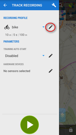
- Training auto start - defines a training audio scheme to be launched simultaneously with the track recording
- Automatic export - sets automatic export of recorded track to files or web services. The setting dialog is the same as in the Track export except of a new button - Set - that confirms the export selection
- Live tracking auto-start - defines a Live tracking event to be launched simultaneously with the track recording
manual/user_guide/tracks/recording/profiles_settings.1474368759.txt.gz · Last modified: 2016/09/20 12:52 (external edit)
Except where otherwise noted, content on this wiki is licensed under the following license: CC Attribution-Share Alike 4.0 International
