Translations by gtranslate.io
Sidebar
manual:user_guide:settings:lang_units
Table of Contents

Language & Units
Language
App language
Language of all texts in the app - titles, descriptions…

Changing language requires internet connection - other language packs are not part of the app.
The language list displays also availability of particular languages in percents. Help with translation button in the bottom shortcuts to Locus crowdsourced translation page. If you are interested in Locus development and have proper language skills, you are welcome!
Text-to-speech
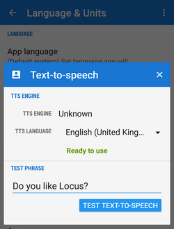 TTS is necessary for navigation, guidance, audio coach and other voice alerts across the app.
- TTS Engine - select from a list of TTS software installed on your device.
- TTS language - each TTS software has its own language portfolio. Select your language. Functional selection is marked “Ready to use”.
- Test phrase - write any phrase to test your TTS setting
Coordinates
Type of coordinates
Select type of coordinates to display in the top panel:
World
- Lat/Lon (WGS) - classic geographic coordinates, the most widespread
- MGRS - military coordinate system
- Maidenhead - Maidenhead Locator System
- Open Location Code - OLC, also known as plus codes, encodes location into a form that is easier to use than showing coordinates in the form of latitude and longitude. More info here >>
- UTM - Universal transverse Merkator
Czech republic
- S-JTSK - Systém jednotné trigonometrické sítě katastrální - a rectangular coordinate network used in geodesy in the Czech Republic and Slovakia
Ireland
- OS Irish Grid - modified OSGB 1936 used in United Kingdom
Israel
- Israeli CS grid
- Israeli TM grid
Netherlands
- Dutch Grid (RD)
New Zealand
- NZGD2000 - New Zealand Transverse Mercator 2000
Switzerland
- CH1903/LV03
United Kingdom
- OSGB 1936 - British National Grid
Advanced users (surveyors, professionals…) who want to use Locus Map for specific tasks can define custom coordinate systems >>
Lat/Lon format
WGS Latitude/longitude format to display:
- xx,xxxxx°
- xx°xx.xxx' - used in geocaching
- xx°xx'xx.xx“ - the most accurate
Units
Distance
Select from several combinations of following systems:
- metric - m, km
- imperial - ft, yd, mi
- nautical - m, nmi
Area
Select units common in your location and field of use - m2, ha, km2, ft2, yd2, acre, mi2, nmi2
Altitude
Units of height above the sea level - meters or feet
Speed
Select units common in your location - km/h, miles/h, nmi/h, knots
Angle
Select units you are used to work with - degree, angular mil, Russian mil, US artillery mil
Slope
Select percent or degree
Temperature
Celsius or Fahrenheit
Energy
Joules or calories
Weight
kilogram or pound
manual/user_guide/settings/lang_units.txt · Last modified: 2019/07/10 12:17 by mstupka
Except where otherwise noted, content on this wiki is licensed under the following license: CC Attribution-Share Alike 4.0 International
