Translations by gtranslate.io
Sidebar
manual:user_guide:points:export
This is an old revision of the document!
Table of Contents

Points Export
What is export for?
Points are exported to another mobile, to a desktop application or web service for further processing - displaying in a different environment, background, for editing etc.
Instructions:
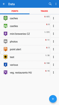
1. Select point/s
Single point
- Points manager - select folder > tap the point to open its detail >
 “more options” >
  export
- Map screen - tap the point on map > tap its label to open its detail > “more options” > export
Group of points
- Multiple points - Points manager > open folder >
 tools > check points you want to export > export
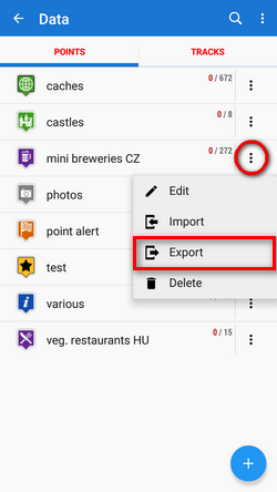
- Whole folder - Points manager > folder
 action menu > export
2. Set export parameters
- Export format of the file is at the very top of the dialog. By tapping it you can change it into another one:
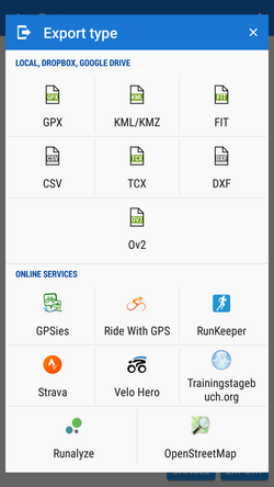
(only file formats can be selected. The dialog is common with the track export so it contains also web services. None of them accepts points)
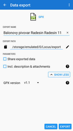
- Export name - the name of the export file, usually pre-filled according to the point/folder name. Can be edited.
- Export path - define where to save the exported file. You can select local memory, Dropbox or Google Drive (both apps must be installed first).
- Parameters - change according to selected export format:
 GPX - GPS eXchange format is an XML based text format used for handling points, tracks, and routes. Locus fully supports all valid tags. A more detailed description of GPX format is available on this Wikipedia page.
 - Export only visible - exports only points actually visible on the map
- Share exported data - enables to share the export file in Dropbox or other services available in your device
- Insert a formatted description - creates a HTML table with the file description - it is not recommended if re-import or further GPX editing is planned
- GPX version - optional setting for experienced GPS device users
 KML/KMZ - Keyhole Markup Language is XML based plain text format with really wide range of usage. Since the version 2.2 KML format is standardized by OGC so it is used by many web/desktop/mobile applications as well as Locus Map. It is usable for export of both points and tracks.
- parameters identical to GPX export but one:
- Include icons and attachments - enables packing data into one KMZ file - icons, photos etc.
 CSV - (Comma Separated Values) is a common, universal and relatively simple file format that is widely supported by many applications. Usable for export of both points and tracks. Parameters are just Export visible and Share.
 DXF - (Drawing eXchange Format) - comes from CAD software. Usable for export of both points and tracks. Except of already mentioned parameters it enables to:
- Display altitude - displays altitude of exported points as text information
- Real (3D) altitude - moves exported points into real height above the sea level and displays them in 3D
 OV2 - TomTom format for POI database. The same parameters as CSV.
Export of Geocaches
When exporting multiple geocaches to a GPX file all of them are checked if they contain complete information (listing etc.). If they contain just basic info about coords, terrain, difficulty, they are automatically updated - export of geocaches takes a bit more time than in case of ordinary points.
If you want to avoid this updating, set your Geocaching4Locus addon so that it downloads all information about caches directly (Settings > Download > uncheck “Basic info only”)
manual/user_guide/points/export.1567086242.txt.gz · Last modified: 2019/08/29 15:44 by mstupka
Except where otherwise noted, content on this wiki is licensed under the following license: CC Attribution-Share Alike 4.0 International
