Translations by gtranslate.io
Sidebar
Add this page to your book
Remove this page from your book
This is an old revision of the document!
Table of Contents

WMS Maps
About
WMS (Web Map Service) is a standard protocol for serving georeferenced map images over the Internet that are generated by map servers using data from a GIS database. These are usually statistical maps that are mostly provided by government organizations (but also by many others). For more info, read this Wiki page.
Locus Map offers a variety of worldwide sources that can be displayed or you can enter a direct URL to activate any WMS source you wish.
This option is fully available only to Locus Map Pro users.
Displaying WMS Maps
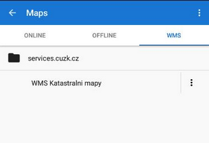
Choose WMS tab in the Maps Manager (the tab can be switched off so select ![]() Action menu > Visible tabs and check WMS). The tab is empty after the Locus Map installation so you need to tell Locus Map which WMS source to display by tapping buttons in the Action bar:
Action menu > Visible tabs and check WMS). The tab is empty after the Locus Map installation so you need to tell Locus Map which WMS source to display by tapping buttons in the Action bar:
WMS maps display always in an overlay above your active map (online, personal or Locus Maps).
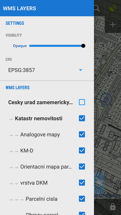
When you launch a WMS source a list of available layers and a opacity slider appears - select layers to display, adjust their visibility above the active map and confirm. Be aware that not all layers are visible in all places and in all zoom levels.
 The WMS source appears in your Maps Manager WMS tab in a folder named by its provider. Long tap at a source displays an information window about the source provider, author, contacts, possible fees and further description.
Action menu at the WMS source provides following:
- Details - information window mentioned above
- WMS Layers - available layers in the source
- Center Map - centering the map at the screen center of your phone in case your position is outside the map
- Re-initialize map - reloads required information from WMS server and sets the map to default values
- Disable - hides selected WMS layers in the map
- Delete - deletes the WMS source from the list
WMS Map Screen
After a WMS map display two new control buttons appear in the upper left corner:
 displays the opacity slider and active WMS layers list - check or un-check layers to display or hide.
  displays a particular WMS feature information - aim the screen center at a WMS object on the map and tap the button. In case the object contains some additional information it displays in a pop-up window.
WMS Maps Sources
 Locus Map supports WMS specification versions 1.1.1, 1.3.0
Current WMS support does not have any mechanism for tile caching. All data are stored only in your device's temporary memory.
Recommended WMS Map Sources List >>
Use Add to Locus links directly in your phone web browser (access to this page is also from your Locus Map Manager WMS tab).

