Translations by gtranslate.io
Sidebar
manual:user_guide:maps_external
This is an old revision of the document!

External Maps
Locus Map can also work with external offline maps acquired from other sources - PC software, cartography publishers and other map providers. It is necessary to copy these maps into your phone's memory or on SD card and tell Locus Map where to find these map data:
- copy your external map directly into Locus Map's default directory Locus/Maps - Locus Map imports them at its start (if you copy the map into this folder when Locus Map is ON it is necessary to re-start the app to import the maps
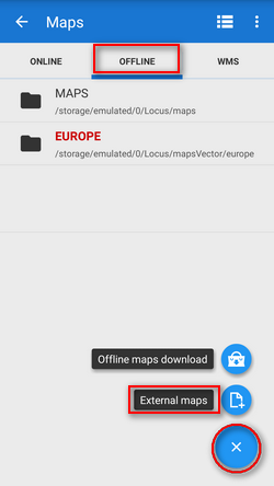
- if you want to add maps from another directory in your phone memory or from SD card:
- tap
 Add maps button in the bottom right corner
 - select
 Add external maps
 - browse your phone or tablet's memory or SD card
- select the directory and confirm
- the directory emerges as a new folder bellow the default Maps folder in the Maps manager Offline tab.
Maps added in one folder are automatically merged. If you want to add maps without merging them, place them into individual subfolders and then add them one by one.
Versions 2.x of Android operation system can not handle files of 2 and more gigabytes. Keep it in mind when downloading your external maps!
If you need a bigger map, download more smaller areas, copy them into Locus/Maps directory, Locus Map will merge them and use them as one file.
Supported Map Formats
There is a huge amount of map file formats and Locus Map is proud to be one of a few to support so many of them:
- SQLite (*.sqlitedb)- plain SQLite database, with a tilestable, that contains x, y, z, image columns with required data. Coordinates are computed by the Slippy map system. SQLite files created by Locus Map when downloading online maps work fine but there can be problems with some SQLites from other sources. Some of corrupted SQLite databases can be repaired >>
- TAR - as we mentioned before it is an obsolete map format, however, with a wide support and available map material. For example famous OZI Explorer. This software uses its own OZFX v2/v3 map format together with a calibration *.map file. TAR format is a very simple archive containing one *.map calibration file (including name, calibration points, datum, projection specifications and more) and map images.
- RMAP - an undocumented map format. Support by Locus Map is limited and not all projections and map format versions are working.
- IMG - Garmin maps format. Locus is able to work with non-paid and unlocked maps in this format but is not able to detect their coverage - therefore some map features like auto-load or Quick map switch do not work with them.
- GEMF (*.gemf) - GEMF Map Store Format is fast and efficient. It enables storing raster map tiles in the same format as SQLite but in faster and more efficient way. Unfortunately it is not widespread much.
- MapsForge (*.map) - The MapsForge project is aimed on support of OpenStreetMap based Android applications. It provides its own binary format for OSM data enabling applications render their own maps on-the-fly from raw information. More on MapsForge homepage.
- SmartMaps - binary encrypted format used for maps by a Czech company PLANStudio. More information can be found here.
- OruxMaps - SQL-based format of maps designed for the OruxMaps application.
If you come across a map file in a format not included in this list and you would like to use it in Locus Map there is no need to worry. There is a lot of desktop conversion software to solve the problem.
manual/user_guide/maps_external.1455704025.txt.gz · Last modified: 2016/02/17 10:13 (external edit)
Except where otherwise noted, content on this wiki is licensed under the following license: CC Attribution-Share Alike 4.0 International
