Translations by gtranslate.io
Sidebar
manual:user_guide:functions:measure
This is an old revision of the document!
Table of Contents

Measuring distance&area
Measuring distance
There are three methods of measuring the distance between two points in Locus Map:
- (1) beeline measuring - measuring of straight distance between two points
- (2) road measuring - measuring distance along the road.
- track measuring - measuring distance that was passed is described in detail in track recording >>
Quick distance measuring
(1) Quickest way of measuring distance between any two points on the map screen.
- go to Settings > Maps > Map objects > Quick measurement - check
- measure distance by touching the screen with two fingers at once. Magnifiers will help you place the measuring points precisely.

Line to GPS
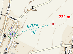
(1) Method of easy measuring of the distance between your actual GPS position and any point on the map.
- go to Settings > Maps > Map objects > Line to GPS - check
- a line with the distance and azimuth stretches between your position and the map cursor
Both methods (1) and (2) are provided by the Add new route&Measure feature:
Add new route&Measure
- Menu > More functions > Add new route & Measure
- the function can be added to the Function panels for quick launch
The feature displays additional controlling items to the main screen as is described in Route planning >>:
Measuring instructions
- make necessary settings - e.g. select routing service if you want to measure road distance using route calculation
- Menu > Settings > Navigation
- or route computing dialog > navigation settings
- set starting point
- shift map screen center at the desired spot - quite accurate method
- select location by the location selector - depending on selected method the starting point location can be defined very precisely, e.g. by coordinates or postal address
- quick add - fastest method but not accurate, places points on the map by plain tapping your finger
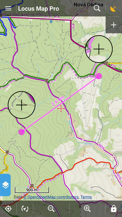
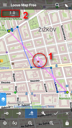
 add waypoints - use any of above mentioned methods to add waypoints - a measuring line stretches between each waypoint showing the distance (1), the total distance is displayed in the upper left corner (2). Tapping the digit changes its units (m > ft > yd)
 remove waypoints - use in case you want to start a different measuring - you can go back by removing points and then repair the measuring by adding new ones. Or you can delete whole route by tap-and-hold.
![]() Route computing - useful for exact road measuring. Turn it on, add waypoints and Locus Map will compute the route between them smoothly along the roads. Always turn the computing function first before you want to compute route between two new waypoints, not vice versa!
Route computing - useful for exact road measuring. Turn it on, add waypoints and Locus Map will compute the route between them smoothly along the roads. Always turn the computing function first before you want to compute route between two new waypoints, not vice versa!
Measuring area
Areas can be measured by the Add new route&Measure function too.
- check Compute area option in the Add new route&Measure tool menu
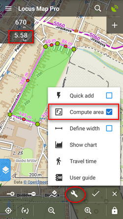
- switch off router-assisted route drawing
- click the line around the measured area
- the area measurement value displays in a box in the upper-left corner under the length box. Tapping the box changes units.
manual/user_guide/functions/measure.1500910727.txt.gz · Last modified: 2017/07/24 17:38 (external edit)
Except where otherwise noted, content on this wiki is licensed under the following license: CC Attribution-Share Alike 4.0 International
