Translations by gtranslate.io
Sidebar
manual:faq:how_to_navigate_offline
This is an old revision of the document!
Table of Contents
How to navigate offline?
Offline navigation is essential for any outdoor traveling. Bad or even no data signal in mountainous, rural or otherwise deserted areas makes online navigation useless.
Locus Map in default settings offers navigation with the help of implemented online services. Firstly it is GraphHopper online navigation service followed by YOURS. If you want offline navigation, you have to install cooperating routing app BRouter, available at Google Play Store >>. Locus Map identifies it in the system and adds it automatically to the routing services portfolio.
BRouter setup
- after installation, launch BRouter
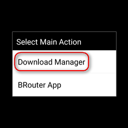
- select Download manager
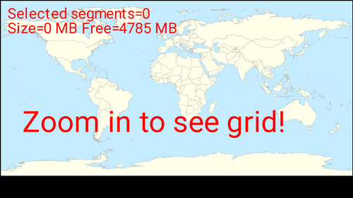
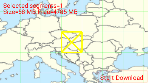
- zoom in and select the area you need for offline routing
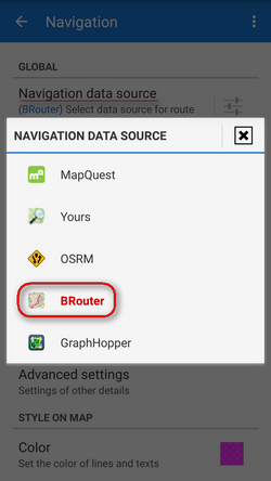
- set BRouter as default navigation data source in Locus menu > settings > navigation > navigation data source
- then start navigation as usual by
 Navigate to function and you will be navigated offline.
BRouter remains set as default also for engine-routing-assisted drawing in Add a new route function
Advanced options
Although BRouter user interface looks quite simple, the app offers quite a lot of various settings, creating custom navigation profiles etc. A rich source of info and tips is this wiki-blog >>. BRouter provides also a web app, enabling route planning on a big PC screen and consequent export to GPX file and then to Locus Map.
GraphHopper
An alternative to BRouter is routing software GraphHopper. An unofficial Locus GrapHopper add-on is still in development but is free to use. It is not available at Google Play yet – all necessary links and relevant information gather in this forum thread >>.
Is this article useful for you? Please rate it: {(rater>id=1|name=faq_how_to_navigate_offline|type=rate|headline=off)}
manual/faq/how_to_navigate_offline.1574784770.txt.gz · Last modified: 2019/11/26 16:12 (external edit)
Except where otherwise noted, content on this wiki is licensed under the following license: CC Attribution-Share Alike 4.0 International
