Translations by gtranslate.io
Sidebar
manual:user_guide:maps_locusmaps
Table of Contents

LoMaps
About
Locus Map developing company Asamm Software provides its own maps based on OpenStreetMap Data and rendered directly in Locus Map application via MapsForge toolbox:
- LoMaps cover the whole World in map packets covering individual states
- they are purchased and downloaded solely for offline use
- they are smaller in data size than maps downloaded from the online mode
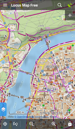
- LoMaps can be switched into several themes: hiking/biking, skiing, town plan and road map. Each theme is based on the same map data but displays different layers and symbols according to the user's needs.
The level of map details varies according to the map area. As OpenStreetMap project depends on its internet-connected contributors some less internet-covered parts of the World are not properly mapped.
LoMaps content
- map data - line, space and point objects
- offline addresses - beginning with LoMaps 2016/04/01- addresses can be searched for
- points of interest - can be clicked in order to display their detail, can be browsed or selectively displayed
- elevation data - necessary for terrain shading, route elevation profile rendering etc. It can be downloaded additionally after LoMaps packet download.
LoMaps purchase and download
LoMaps can be purchased in ![]() Locus Store that is accessible by two ways:
Locus Store that is accessible by two ways:
- from the Map Manager - select Offline Maps tab in the Map Manager and tap the
 Add maps button in the bottom right corner - select
  Offline maps download
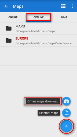
- from the Main Menu - selectStore
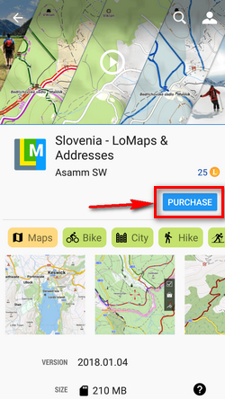
When you find your desired map, select it and the map information screen appears. It contains important information about date of the map update (LoMaps are updated approx. once in two months) and its size in MB before and after unpacking. To start downloading just confirm the purchase.
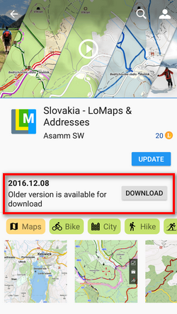
Purchased version of a LoMap can be downloaded repeatedly for period of its availability in the Store. When the particular version is not available any longer, it is possible to download next oldest available version of the LoMap for free.
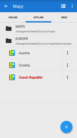
Purchased maps appear in Offline maps tab of your Map Manager in folders sorted by country.
LoMaps purchasing tutorial
First three LoMaps (various ones, not one LoMap and two updates) are available for free. Then the maps are purchased for virtual currency LoCoins that can be purchased via Google Play in-app billing. More about Locus Map purchasing options see here >>
Updating LoMaps
You can download your purchased LoMaps from the server as often as you like for the whole time of its availability. When your LoMap version is not available any longer, you can download the next oldest available version for free again.
Only if you need the newest LoMap update, you have to buy it. The fee is symbolic, e.g. whole California can be obtained for cca 0,7 USD.
Examples of LoMap statuses
- LoMap is not purchased
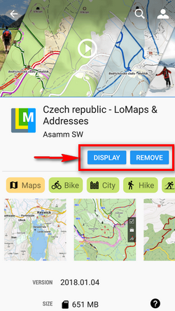
- LoMap is purchased and downloaded, no update is available - you can display the map or remove it from your device memory
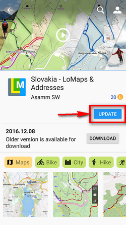
- LoMap update is available - you can purchase the update
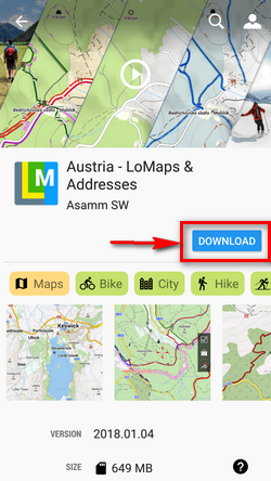
- LoMap is purchased but not downloaded, no update available - you can download your LoMap for free
- LoMap is purchased but not downloaded, an update is available too - you can download your LoMap for free or you can purchase the update
Check for updates
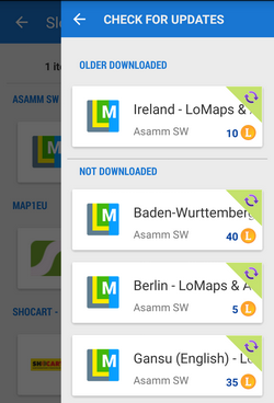
Locus Map does not update your purchased LoMaps automatically, it is always up to you. Check for your updates in Locus Store > User Profile > Check for updates. The updates are divided into two categories:
- older downloaded - purchased LoMaps packages are downloaded but not updated
- not downloaded - purchased LoMaps packages are not downloaded nor updated
Displaying LoMaps
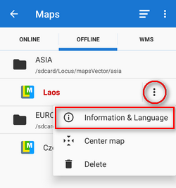
Downloaded maps are accessible from the Maps Manager, Offline maps tab.
To open the map just tap it. If your position is out of the map, select Center map from the Map menu.
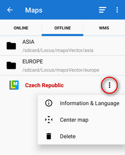
To delete the map from the list and from your phone, select Delete from the Map menu. To display the map information window select Information&language from the map menu:
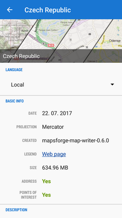
The window contains a general overview of the map type, map language switch and following information:
- Date - date of map data
- Projection - used map projection. Currently only Mercator projection is allowed
- Created - version of the MapsForge Map Writer plugin used for the map rendering
- Legend - link to the LoMaps legend website
- Size - size in your memory
- Address - Yes/No - data are (not) downloaded
- Points of interest - Yes/No - data are (not) downloaded
- Description - map metadata if there are any, testimonials etc.
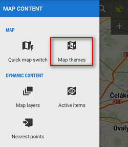
Map themes
LoMaps can be switched into following themes:
- Hiking&cycling map - contains marked hiking paths, cycling paths and trails, contour lines, guideposts and a dense network of country roads

- Ski map - includes ski slopes and cross country skiing trails

- City map - general use in cities

- Road map - suitable for driving


Switching map themes
Each vector (or other) map that contains themes or theme layers activates option to switch these themes. There are a few ways how to do this:
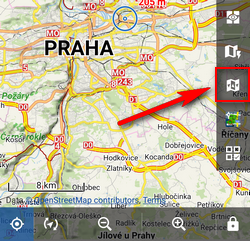
All these methods display the theme menu:
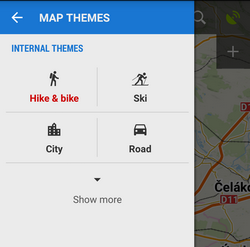
Here you can select the map theme - internal or external (custom). Some themes contain also switchable layers of specific datasets. This way you can fine tune your map content:

Map language
Names of cities, towns and villages in exotic destinations can be sometimes difficult to read for Westerners:
 OpenStreetMap data, therefore, contain transcription of local names in English (or sometimes also other languages). The language switch can be found in a LoMap detail screen:
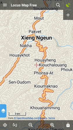
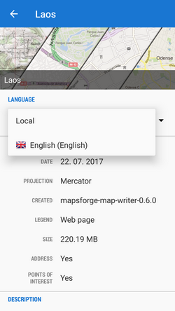 Open the language menu and select language you understand. Not all names are transcribed, it depends on activity of the local OSM mapping community. The same map with English-transcribed names
LoMaps legend
Table of LoMaps symbols can be found here >>
manual/user_guide/maps_locusmaps.txt · Last modified: 2023/05/05 11:28 by mstupka
Except where otherwise noted, content on this wiki is licensed under the following license: CC Attribution-Share Alike 4.0 International
