Translations by gtranslate.io
Sidebar
manual:advanced:map_tools:osm
Table of Contents
Mapping of OSM
Author: berkley
Discussion: forum.locusmap.eu
Locus Map allows to use great vector maps with map data from OpenStreetMap. As OSM is an open project everybody can improve the map quality. This How-To is not meant to cover all the details for mapping on OSM, but it should help you, to get a step into it. It's quite easy to put roads, tracks, house numbers and POIs on the map. OSM really made some great work to help new users getting started. And you - as a Locus user - can be one of them!
What do you get for mapping on OSM? Nothing! Yes, correct, NOTHING! Nobody gets anything. No Money! No fame! No honor!
So why should you do this? Because you are using maps with data that has been collected by other volunteers around the world. It's just the good feeling to help someone else and say thanks by giving something back to the community.
But enough talking now, time to get started!
Mapping
When it comes to mapping by yourself, you need to have an account on OpenStreetMap.org >>
Registration is free and takes just a minute. After registration, you can go directly to your place and hit the “edit” button. But, it is always a good idea to have some recorded tracks from missing roads in your Locus directory. That way, it is easier to map high quality data. For better understanding you can have a look at these very detailed tutorials on YouTube. It is a three part series, which covers and explains almost all aspects for mapping on OSM:
So far so good - this wouldn't be an article on the “Locus knowledge base” without mentioning a word how Locus can help you on this task.
Send your track to your OSM profile
![]()
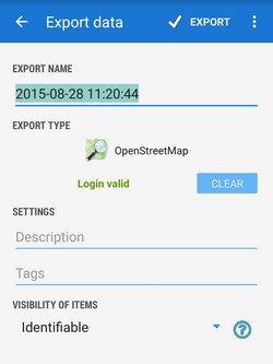
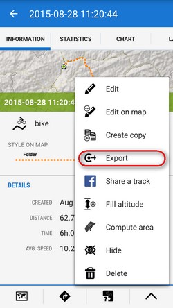
After recording a track with unmapped roads, simply go to “Data > Tracks > Chosen Category”, click on the track you've just recorded and hit export. On first time use, you will need to go through a simple authentication process. Enter the login data from http://www.openstreetmap.org/ and go ahead.
Now, Locus sends your track directly to the GPS traces in your OSM account. You can choose them to map the missing roads. This can't be done more easily!
Sometimes it takes a while untill OSM servers have processed your upload. Please be patient.
Map editing
Now that you have your track in your OSM account, you can go right ahead and edit the map. Use “Potlach 2”, so you don't have to install anything on your computer. But feel free to use any of the other editing options. “Potlach 2” is just easy to start with. So I recommend this. But “JOSM” is way more powerful.
I hope you have watched and understood some tutorials, because I will not explain here, how you use these tools. There are really better places to learn more details about OSM.
So simply do the following:
- Upload tracks from Locus
- Display them on the map
- Draw new roads
If you have problems or questions with something on OSM, ask them! ;)
There are really nice people willing to help you out with your problem. There are also support forums and you can even find and contact mappers around you. Give it a try!
Appendix
When you once got used to the vector maps in Locus and enjoyed their good quality, please share some of your time, to give something back. It's a Win-Win-Win-Win-Win-situation.
For further information about the OSM project, please visit these sites:
manual/advanced/map_tools/osm.txt · Last modified: 2015/09/03 13:08 by mstupka
Except where otherwise noted, content on this wiki is licensed under the following license: CC Attribution-Share Alike 4.0 International
