Table of Contents

GPS & sensors
System settings of GPS in your device are superior to all Locus GPS settings - the system GPS being turned off or if Locus does not have permission for accessing GPS (e.g. for battery-saving reasons) especially in stand-by mode may result in incorrect GPS positioning that influences many Locus features. Check your system settings first!
Global
Run at app start
Sets the way GPS turns on at Locus Map startup:
- Always - GPS turns on always when Locus Map is started
- Previous state - GPS turns on or stays off according to last Locus Map session
- Never - GPS never turns on at Locus Map start
Altitude manager
Orientation
Compass
Allows to choose either built-in hardware compass or GPS-calculated azimuth for orientation that is essential for map rotation and the compass screen.
- Hardware compass - more suitable for slower speeds, e.g. walking, as it does not require movement to detect direction unlike GPS.
Mobile hardware compass is very sensitive on nearby magnetic metals and may display malformed values in their close presence, e.g. magnetic flip-cases or steel steering bars.
- Orientation via GPS - more suitable for car navigation due to magnetic components in the car that can affect performance of the hardware compass.
- Auto-change - shifts bearing automatically between hardware compass and GPS according to pre-defined critical speed.
Use true bearing
Sets navigation by true bearing instead of magnetic bearing.
Compatibility mode
Orientation is computed by an alternative method. Suitable for some devices.
Notification settings
Position acquired
Notifies when your device acquires GPS location. Opens notification settings screen with several options to define the sound and vibration alert (beep, any sound from your phone library…).
Position lost
Notifies when your device loses GPS location. Opens notification settings screen with several options to define the sound and vibration alert (beep, any sound from your phone library…).
Disable location
Disable when app is hidden
Disables GPS when the screen is turned off or the app is minimized and GPS location is not required by any other function
GPS ON for track recording
Keeps GPS on during the track recording even if the recording is paused.
GPS ON for guidance
Keeps GPS on during guidance even if the app is minimized and screen is off.
Bluetooth GPS
Launches the Bluetooth manager to enable GPS from a bluetooth device instead of the internal GPS. The advantage is better GPS accuracy and lower phone battery consumption.
Advanced settings
GPS auto-off
Allows automatic turning on/off of your device GPS unit in order to save the battery life. Pre-defined conditions:
- GPS update interval - sets time interval of GPS switching on and locating the device. Values of more than 60 seconds save battery life.
- Min accuracy - sets minimum GPS locating accuracy to keep GPS on. When the accuracy is lower due to few detectable satellites, the GPS turns off.
- Max search time - sets maximum time of GPS signal searching. If the GPS fix is not secured within this period, GPS turns off.
- Keep auto-off enabled - keeps GPS auto-off enabled even if Locus Map is active and screen is on.
This option is not available on devices running OS Android 12+ due to its newest restrictions of certain automatic actions running in the background.
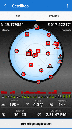
3D skyplot mode
Switches between 2D and 3D display of the skyplot that is available under the GPS/compass button on the main screen:
Google Services assisted location
More stable and battery efficient location method on some devices. Using Fused Location Provider for getting location of the device. Fully functional provided Google Services have GET_LOCATION permission.
NMEA recording
Enables recording GPS NMEA to data/nmea directory when GPS is on or in time of active track recording. More about NMEA >>
Reset A-GPS data
Forces GPS to reload online Assistant GPS data to improve its startup performance. More about A-GPS >>
GPS accuracy circle
Displays a circle around your actual position describing accuracy of received GPS data: