Table of Contents
Points & Tracks
Menu > Settings > Maps > Points & Tracks
POINTS
Tap on point
Sets default action after tapping a point on the map:
- Popup - a small information label popping right above the point, more info here >>
- Screen - whole screen window with all information you need, more info here >>
Points popup content
Sets the behavior and content of the point information window.
Basic setting:
- Never - points window appears only after tapping the point
- On hover - points window appears when the map is shifted over the point with the center cross
- Always - always visible point labels
Basic setting also switches altitude value display on/off.
Available context menu items:
- Navigate to, Guide to, Compass, Edit, Hide, Delete
Geocaching items:
- Hint, Load all waypoints, Log your visit
New point default location
When creating a new user point on map, use one of following default methods of location:
- GPS fixed position - creates point on actual GPS position of the user
- Map screen center - creates a new point at actual position of the cursor in the middle of the map screen
Map icons size
Sets size of icons on the map from 50 to 300% of a normal size.
TRACKS
Tap on track
Sets default action after tapping a track:
- Popup - a small information label popping right above the track, more info here >>
- Screen - whole screen window with all information about the track, more info here >>
- Edit mode - a small label plus bottombar with editing options
Track pop-up content
Sets a label at a track starting point:
- Do not show - starting point is without label
- Simple - label shows only date/time of start
- Complex - label shows date/time of start, distance passed, total positive and negative elevation
And available items in the track popup window - trackpoint No., display on chart, track detail, edit, edit on map, navigation/guidance, hide and delete 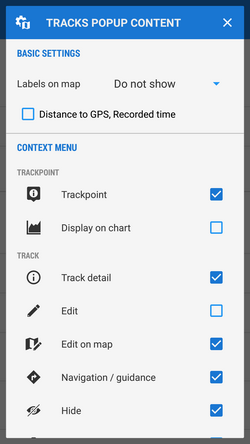
Track icons
Defines start/stop icons of visible tracks:
- No symbol
- Dot
- Icon
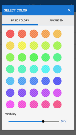
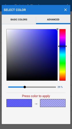
Track color and transparency
Basic setting of color and transparency of all tracks and routes globally for the whole app. There are two color selection modes - basic and advanced.
Track width
Basic setting of width of all tracks and routes in pixels globally for the whole app.