Translations by gtranslate.io
Sidebar
manual:faq:how_to_add_map_shading
Table of Contents
How to work with elevation data in Locus?
Elevation data are necessary for many aspects of work with Locus:
- base of calculation of route elevation gain when planning.
- definition of elevation of point objects (POIs, geocaches…)
- database for dynamic elevation tool (displays elevation on the position of the map cursor)
- database for rendering terrain shading
- filling elevation of imported Map items in case the file contains at least one route
- elevation of routes calculated by external navigation engines (BRouter, YOURS, ..)
- elevation gain displayed with guiding lines or lines to GPS location
- database necessary for pressure sensor calibration
- calculation of Trip time
Please do not confuse with current altitude that is obtained from GPS data together with values from the barometric pressure meter in your device (if applicable), see more >>. Current altitude values are also used for calculating elevation gain in recorded tracks.
Where to get them?
To use all features above, it is necessary to download elevation data. There are a few methods on how to get them:
Offline maps
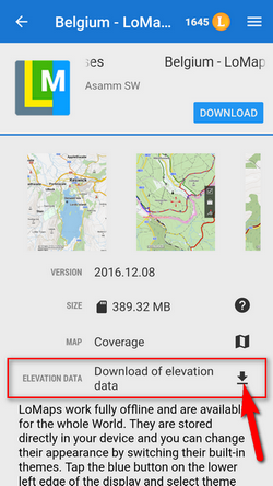
LoMaps and other offline maps from our map partners offered in Locus Store in packages cover the whole World. Each map package contains elevation data that can be downloaded separately for free:
Creating or editing a point of interest
- Add a new point of interest or open detail screen of an existing point located in the area that we want to cover with elevation data
- find Elevation field and if it is empty, tap the button GET next to it
Group of points
- select points (check them) in a desired point folder
- tap
 More and
  Fill elevation in bottom panel
Track or route
- open a track/route detail screen
- tapMore and Fill elevation in bottom panel
Custom elevation data sources
- Viewfinderpanoramas.org - SRTM3 data enhanced in mountainous and polar areas. Resolution 3“.
- Sonny's LiDAR Models of European Countries - very accurate data obtained from LiDAR mapping missions, covering many European countries. Resolutions 1” and 3”.
- store the data in Locus/data/srtm directory and restart the app
Map shading
Map or terrain shading serves better readability of the displayed terrain relief. Locus offers three modes:
- hill shading - simulating covering of the landscape by sun shade
- slopes - highlighting slope gradients of >30°, >35° and >40
- colored elevation - elevation levels are differed by colors (e.g. lowlands are green, mountains brown).
Instructions
Go to Settings > Maps > Advanced > Map shading > Enable (select which type of map should display the shading)
manual/faq/how_to_add_map_shading.txt · Last modified: 2023/05/05 12:11 by mstupka
Except where otherwise noted, content on this wiki is licensed under the following license: CC Attribution-Share Alike 4.0 International
