Table of Contents

Points Import
About
Points import is used when you want to work with points from outside of Locus - websites, apps, add-ons etc. Either you choose the data yourselves or Locus Map receives them.
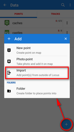
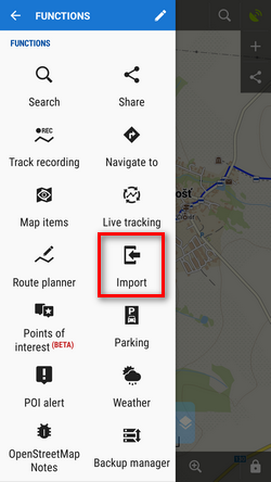
1. Launch import
There are a few ways:
- Menu > Points >
 > Import
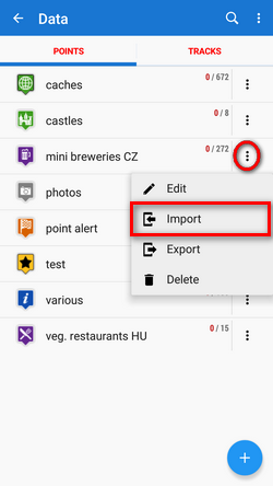
- (Menu) > Points > any folder menu > Import - imports directly into the selected folder
2. Select the file to import
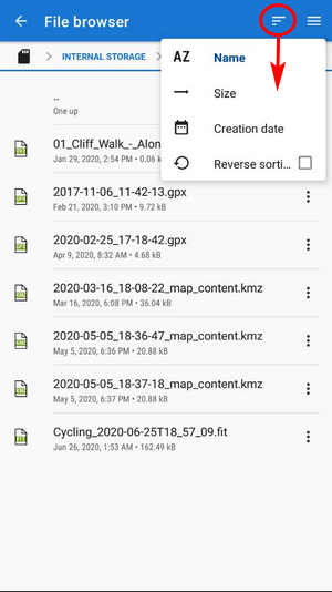
Locus file browser opens the last used memory drive. Importable files are in full color and are clickable (more about supported formats see below):
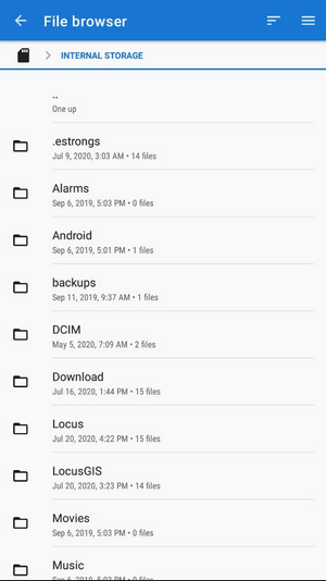 You can sort the files by name, size and creation date:
 Other available drives can be switched from the topbar menu:
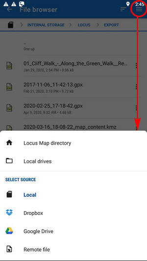
- Locus Map directory - the content of the app's main working directory
- Local drives - list of local memory drives (usually the Internal and external SD card code name)
- Local - the content of the app's main working directory
- Dropbox - contents of your Dropbox. Dropbox login is required when using the drive for the first time. Logout option is included.
- Google Drive - contents of your Google Drive. Google Drive login is required when used for the first time. Logout option is included.
- Remote file - a field for inserting a URL of a remote file stored on the internet
3. Select where to import
After selecting the file or receiving it from some external application or add-on Locus Map analyses it and modifies the import dialog according to the content - the dialog can process points or tracks or both of them at once.
Point import dialog
Appears when the imported file contains just points:
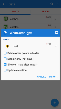
- topbar displays the file name
- Folder selector - selects the folder into which the file will be imported. It is possible to create a new folder directly from the menu. If you start import from a folder action menu in Points manager it is already pre-selected.
- Delete other points in folder - removes all other points from the selected folder before the import
- Display only (not save) - points are just displayed on the map screen - useful for a quick preview of the imported file
- Show on the map after import - displays imported points on the map when the import is finished
- Update elevation - adds or updates the value of imported points' elevation (both only if the offline elevation data is available)
- Cancel - aborts the action
- Import - confirms the action
Supported file formats
Locus Map is able to import the following file formats:
 KML and KMZ
Supported both for Import and Export
Keyhole Markup Language is XML based plain text format with really wide range of usage. Since the version 2.2 KML format is standardized by OGC so it is used by many web/desktop/mobile applications as well as Locus Map.
 GPX
GPX
Supported both for Import and Export
GPS eXchange format is an XML based text format used for handling points, tracks and routes. Locus fully supports all valid tags. More detailed description of GPX format is available on this Wikipedia page.
 OpenAir
OpenAir is a special format used by aircraft pilots and navigators for defining air spaces and areas.
- LOC
Location file format is free but a little bit limited format for importing POIs or waypoints
 Ov2
Ov2
TomTom format for POI database.
- Upi
Sygic format for POI database.