Table of Contents

Navigation
Locus Map provides two kinds of navigation:
Navigate to...
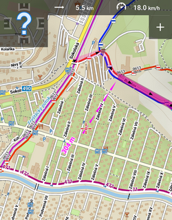
Standard turn-by-turn navigation with voice orders from point A to point B with route calculated by an external routing service (called also navigation data source). Locus Map supports several online routing services and you can of course navigate also offline. The routing service calculates the route according to selected navigation profile (activity or means of transport) - car, bicycle, foot etc. In case of online routing services it is necessary to maintain the internet connection. More info >>
Navigation along a route
Follows user-defined or imported routes. Locus Map renders voice navigation commands automatically from the shape of the route. More info >>
Control Panel
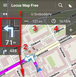
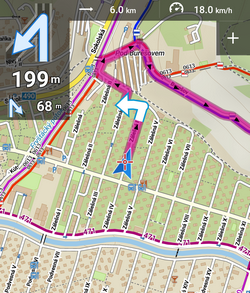
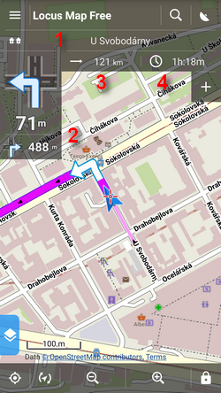 Consists of the street name/road number indicator (1), indicator of the shape and distance of the next two turns (arrow box)(2) and two adjustable fields (3,4) that can display:
- Distance to target (3) (default)
- Time to target (4) (default) - estimated time calculated upon your average speed
- Time of arrival - estimated arrival time calculated upon your average speed
- Time to next junction - time to the next crossroads where the direction will be changed
- Time - device clock
- Altitude - current altitude of the user, calculated from GPS or the device barometer
- Speed - current speed
In some cases the street name/road number indicator may be empty as the navigation source does not have it in its database.
Control Menu
Can be displayed by tapping the arrow box.
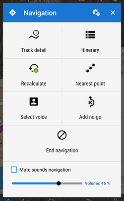
- topbar contains a button to navigation settings
- Route detail - displays screen with detailed info about the route
- Itinerary - list of turning points along the route
- Recalculate - manual trigger of route recalculation and indicator of selected navigation profile. Short tap recalculates the route in selected navigation profile. Long tap opens a menu of other available profiles so the the route can be recalculated in a different profile.
- Nearest point - shifts the map to the nearest route point
- Select voice - displays selection of installed voices and text-to-speech
- Add no-go - inserts an area to avoid on the place of the map cursor
- End navigation - stops navigation and deletes the calculated route
- Volume slider and Mute check-button - sets volume of voice commands
Settings
Here you can set your navigation data source, voice commands etc. More info >>
Leaving the route
When you are forced to leave navigated route Locus offers several ways how to lead you back on it (or to your target):
Guidance
Locus leads you to the nearest point of the route by a guiding line. It displays also distance to it (and other values if you set them in guidance settings).
Auto recalculation - route priority
Selected routing service recalculates your way back to the nearest place on your original route. This option is recommended for navigation along a route:
More info >>
Auto recalculation - point priority
Selected routing service creates a new route leading to the nearest via point or to the finish of the route. This option is recommended for point-to-point navigation:
More info >>
Notification
Locus can notify you when you leave your navigated route - either by voice (it informs about direction and distance of the nearest route point), by a sound, beep or vibration. More info >>